


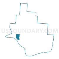
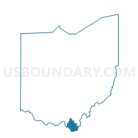
UPPER 1 Voting District, Lawrence County, Ohio
About
Outline

Summary
| Unique Area Identifier | 648459 |
| Name | UPPER 1 Voting District |
| County | Lawrence County |
| State | Ohio |
| Area (square miles) | 5.04 |
| Land Area (square miles) | 5.00 |
| Water Area (square miles) | 0.03 |
| % of Land Area | 99.36 |
| % of Water Area | 0.64 |
| Latitude of the Internal Point | 38.57514810 |
| Longtitude of the Internal Point | -82.68992300 |
Maps

Graphs
Select a template below for downloading or customizing gragh for UPPER 1 Voting District, Lawrence County, Ohio


Neighbors
Neighoring Voting District (by Name) Neighboring Voting District on the Map
- ELIZABETH 2 Voting District, Lawrence County, OH
- HAMILTON Voting District, Lawrence County, OH
- IRONTON 1D Voting District, Lawrence County, OH
- UPPER 3 Voting District, Lawrence County, OH
- UPPER 4 Voting District, Lawrence County, OH
Top 10 Neighboring County Subdivision (by Population) Neighboring County Subdivision on the Map
- Upper township, Lawrence County, OH (15,418)
- Elizabeth township, Lawrence County, OH (2,969)
- Hamilton township, Lawrence County, OH (1,772)